Land Surveying Services
The surveyors at Pioneer Design Group maintain personalized, "hands-on" service with every job no matter how large or small. Our staff is comprised of trained professionals and technicians who are skilled in producing detailed base maps utilizing a wide range of instrumentation. From rag tapes and sketch pads to the latest technology including robotic optical total stations, GIS and high speed computer work stations, our experienced staff employs an extensive selection of equipment to deliver projects on time and on budget.
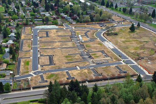
We specialize in providing detailed surveys that are vital to completing complex subdivision projects; these subdivision projects still constitute the bulk of PDG's current portfolio of work on hand. Such surveys encompass a variety of field and office procedures ranging from general topographic work to roadway profiling and cross sectioning. All of these endeavors are now accomplished with the aid of the latest in electronic data collection hardware and software, enabling the collection of large amounts of data quickly and accurately. It has also proven to be highly adaptive and compatible with various government agencies and other planning and engineering firms.
Pioneer Design Group serves both private and public clientele, providing surveying services related to infrastructure improvements and development:
- Property research
- Boundary & topographic surveys
- Property line adjustment surveys
- Subdivision platting
- Site surveys
- Subsidence monitoring
- Construction staking
- Elevation certifications
- Foundation surveys
- Mortgage surveys
- Underground utility location surveys
- A.L.T.A. surveys
- Legal descriptions